Caistor Township
Modern Municipalities:
-> INFO icon on map
Sources for Names:
-> see Maps /w Names
-> see Directories
-> see Census
Search by Surname:
-> scroll to bottom
Transcription Progress:
-> see Sources below
Land Divisions:
Line Maps:
-> see Map Key below
Photo Details/Credits
Names and Locations:
from Maps
from Directories
from Land Patents
Project News
Search onLand for Historical Books
for this County
Immediately use drop-down menu called ‘Filter by Township / Municipality’ (info)
Genealogical Inquiries:
Rootsweb Board for Lincoln Co.
Rootsweb Board for Niagara Peninsula
Location-Related-
or General Comments:
Contact Form

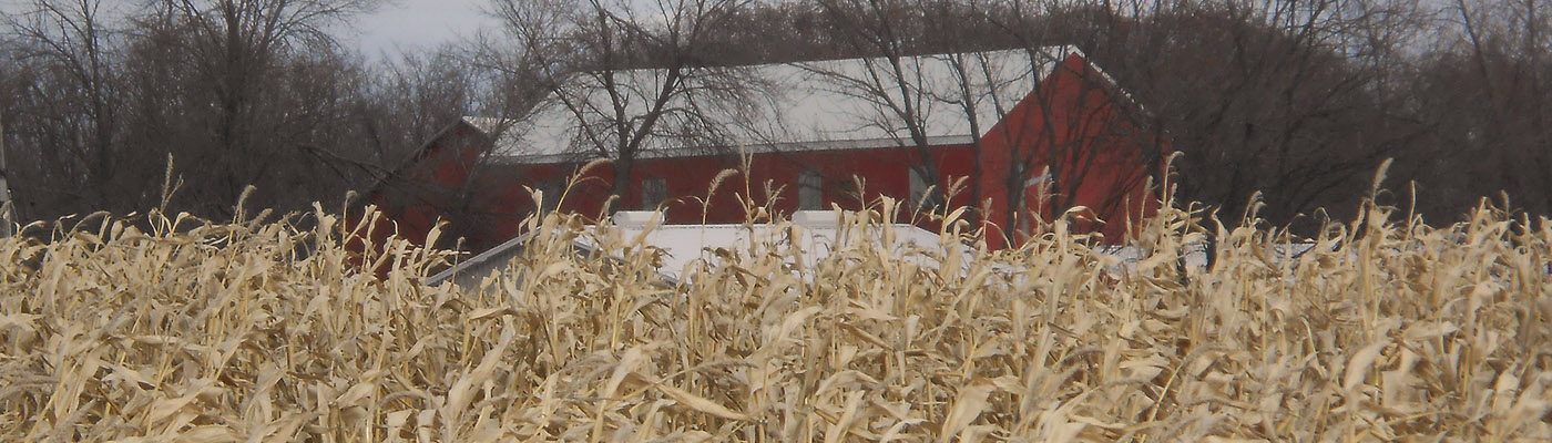
Caistor Twp. in historical LINCOLN Co.
Opened for settlement in 1798. The first non-Indian resident along the Welland River is said to have been a negro named Diamond, who came in 1778, and sold his cabin in 1782 to Henry Dochstader. The pioneer residents were John, James, Alexander and Matthew Lymburner, who came between 1794 and 1796. John built the first mill in 1799 on Lot 6, Concession 2.
Jesse E. Middleton, The Province of Ontario: a History: 1615-1927, published 1927
Click the drop-down titles below:
HINT: Before fine-searching the online maps, verify from the database of transcribed names (bottom).
THE ABOVE LINKS ARE BROKEN. These had been off-site links to the Archives of Ontario's RG-100 Patent Plans. In 2023 the A of O replaced the 'Archives Descriptive Database' with the 'AIMS' database. Please direct inquiries to the Archives of Ontario quoting the RG 1-100 collection and urging for restoration of *large-sized* map images. (I'm always happy to hear from you too).
The names on these maps are not transcribed for the HeritagePIN databases.
Maps at McGill University's Digital Atlas Project cover the Post-Confederation period (late for the scope of this project). Names of land-owners are transcribed at McGill's site.
Click the drop-down titles below:
HINT: Before fine-searching the online directories, verify from the database of transcribed names (bottom).
1865 Lincoln & Welland / Mitchell / free online
Links & Transcription Progress
1870 Lincoln & Welland / Evans / microfiche
Links & Transcription Progress
Find Concession/Lot Locations from the Agricultural Schedules of the Canadian national Censuses.
1842 (limited), 1851, 1861 and 1871.
Click the drop-down titles below:
Finding Aid | (enumerated, but no Ag)
Finding Aid | Search Form – LAC | see table, below
| 1861 District | SubDistrict | Film | PGs: | 22 – | 30 | |
| Lincoln | Caistor | C-1049 | 22 | 23 | 24 | |
| Lincoln | Caistor | C-1049 | 25 | 26 | 27 | |
| Lincoln | Caistor | C-1049 | 28 | 29 | 30 |
* The LAC search form is pre-set to search this District, and for Agricultural schedules only. However, these indexes are significantly incomplete. ALL IMAGES ARE AVAILABLE by page number, in the chart, above.
The 1861 Census Districts | Re: Bothwell, Cardwell & Monck
Contact me with questions, linking errors, etc.
Index – FamilySearch | Confirm – LAC | see table, below
| 1871 District | SubDistrict | Div.* | Film | Images |
| 18 Monck | D Caistor | Div 1 | C-9918 | Link to Start |
| 18 Monck | D Caistor | Div 2 | C-9918 | Link to Start |
* The Enumeration Division must match the corresponding Sched. 1 Personal Census.
Header titles on each census page aren't always fully descriptive of the Districts and Divisions. Rely on indexed information at Ancestry or FamilySearch.
The 1871 Census Districts | Maps of City Wards
Contact me with questions, linking errors, etc.
Log In to a free account at FamilySearch.org.

Use the arrows to advance each page, or browse thumbnails of all images.
| Township | Dates | Film | Images | |
| Caistor | 1863-1877 | 8660940 | Link to Start | |
| Caistor | 1878-1887 | 8660941 | Link to Start |
NOTE: The above table is for records BEFORE 1880, only!
Films marked in red are viewable at LDS Family History Centers.
FamilySearch has begun to transcribe: (incomplete)
Ontario Tax Assessment Rolls, 1834-1899
Search by Surname and Region
See FamilySearch Wiki about Ontario Taxation.
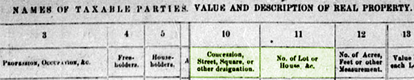
Both Owners and Tenants were assessed for taxes (i.e. Freeholders and Householders).
See the Instructions to Assessors from 1847 Norfolk Co.
| Surname | Incidence | Township | County | Dates | Source | Available online? | Details | Misc |
|---|---|---|---|---|---|---|---|---|
| Bushenbark | 1 | Caistor | Lincoln | 1862 | map | Link to Source | ||
| Butcher | 1 | Caistor | Lincoln | 1862 | map | Link to Source | ||
| Caven | 1 | Caistor | Lincoln | 1862 | map | Link to Source | ||
| Chadbourg? | 2 | Caistor | Lincoln | 1862 | map | Link to Source | ||
| Claus | 1 | Caistor | Lincoln | 1862 | map | Link to Source | ||
| Cleland | 1 | Caistor | Lincoln | 1862 | map | Link to Source | ||
| Clendenen | 1 | Caistor | Lincoln | 1862 | map | Link to Source | ||
| Clough | 4 | Caistor | Lincoln | 1862 | map | Link to Source | ||
| Collier | 1 | Caistor | Lincoln | 1862 | map | Link to Source | ||
| Collins | 1 | Caistor | Lincoln | 1862 | map | Link to Source |
RENFREW Co.
Admaston
Algona North
Algona South
Alice
Allumette Isl.(Qc)
Bagot
Blithfield/Blythfield
Bromley
Brougham
Brudenell
Buchan/Buchanan
Burns
Calumet Isl.(Qc)
Fraser
Grattan
Griffith
Hagarty
Horton
Jones
Lyndoch
Matawatchan
McKay
McNab
Pembroke
Petawawa
Radcliffe
Raglan
Richards
Rolph
Ross
Sebastopol
Sherwood
Stafford
Westmeath
Wilberforce
Wylie
Abinger
ADDINGTON Co.
Adelaide
Adjala
Admaston
Adolphustown
Airy
Albemarle
Albion
Aldborough
Alfred
Algona North
Algona South
Alice
Allumette Island
Alnwick
Amabel
Amaranth
Ameliasburgh
Amherst Island
Ancaster
Anderdon
Anglesea
Anson
Anstruther
Armour
Arran
Artemesia
Arthur
Ashby
Ashfield
Asphodel
Athol
Augusta
Bagot
Bangor
Barrie
Barton
Bastard
Bathurst
Baxter
Bayham
Beckwith
Bedford
Belmont
Bentinck
Bertie
Bethune
Beverley
Bexley
Biddulph
Binbrook
Blandford
Blanshard
Blenheim
Blithfield/Blythfield
Bosanquet
Brant
BRANT Co.
Brantford East
Brantford West
Brighton
Brock
Bromley
Brooke
Brougham
Bruce
BRUCE Co.
Brudenell
Brunel
Bruton
Buchan/Buchanan
Burford
Burgess North
Burgess South
Burleigh
Burns
Caistor
Caledon
Caledonia
Calumet Island
Cambridge
Camden (East)
Camden
Canborough
Canonto
Caradoc
Carden
Cardiff
Cardwell
CARLETON Co.
Carling
Carlow
Carrick
Cartwright
Cashel
Cavan
Cavendish
Cayuga North
Cayuga South
Chaffey
Chandos
Chapman
Charlottenburgh
Charlotteville
Chatham
Chinguacousy North
Chinguacousy South
Christie
Clarence
Clarendon
Clarke
Clinton
Clyde
Colborne
Colchester North
Colchester South
Collingwood
Conger
Cornwall
Cowper
Cramahe
Croft
Crosby North
Crosby South
Crowland
Culross
Cumberland
Easthope North
Easthope South
Eastnor
Edwardsburgh
Effingham
Egremont
Ekfrid
Elderslie
Eldon
ELGIN Co.
Elizabethtown
Ellice
Elma
Elmsley North
Elmsley South
Elzevir
Emily
Emily Gore
Enniskillen
Ennismore
Eramosa
Erin
Ernesttown
Escott
Esquesing North
Esquesing South
Essa
ESSEX Co.
Etobicoke
Euphemia
Euphrasia
Eyre
Gainsboro
Galway
Garafraxa
Garafraxa East
Garafraxa West
Georgina
Gibson
Glamorgan
Glanford
Glenelg
GLENGARRY Co.
Gloucester
Goderich
Gore of Toronto
Gosfield
Goulbourn
Gower North
Gower South
Grantham
Grattan
Greenock
GRENVILLE Co.
Grey
GREY Co.
Griffith
Grimsby
Grimsthorpe
Guelph
Guilford
Gwillimbury East
Gwillimbury North
Gwillimbury West
Hagarty
Hagerman
Haldimand
HALDIMAND Co.
HALIBURTON Co.
Hallowell
HALTON Co.
Hamilton
Harburn
Harcourt
Harvey
Harwich
HASTINGS Co.
Havelock
Hawkesbury East
Hawkesbury West
Hay
Herschel
Hibbert
Hillier
Hinchinbrooke
Hindon
Holland
Hope
Horton
Houghton
Howard
Howe Island
Howick
Hullett
Humberstone
Humphry
Hungerford
Huntingdon
Huntley
Huron
HURON Co.
MacAulay
Madoc
Maidstone
Malahide
Malden
Manvers
Mara
March
Mariposa
Markham
Marlborough
Marmora
Maryborough
Marysburgh North
Marysburgh South
Matawatchan
Matchedash
Matilda
Mayo
McAulay
McClintock
McClure
McDougall
McGillivray
McKay
McKellar
McKillop
McLean
McMurrich
McNab
Medonte
Medora
Melancthon
Mersea
Metcalfe
Methuen
MIDDLESEX Co.
Middleton
Miller
Minden
Minto
Monaghan North
Monaghan South
Monck
Monmouth
Mono
Montague
Monteagle
Monteith
Moore
Mornington
Morris
Morrison
Mosa
Moulton
Mountain
Mulmur
Murchison
Murray
Muskoka
MUSKOKA Dist.
North Algona
North Beverley
North Burgess
North Cayuga
North Chinguacousy
North Colchester
North Crosby
North Dorchester
North Dumfries
North Easthope
North Elmsley
North Esquesing
North Fredericksburgh
North Gower
North Gwillimbury
North King
North Marysburgh
North Monaghan
North Norwich
North Orillia
North Oxford
North Plantagenet
North Sherbrooke
North Toronto
North Trafalgar
South Algona
South Beverley
South Burgess
South Cayuga
South Chinguacousy
South Colchester
South Crosby
South Dorchester
South Dumfries
South Easthope
South Elmsley
South Esquesing
South Fredericksburgh
South Gower
South Marysburgh
South Monaghan
South Norwich
South Orillia
South Plantagenet
South Sandwich
South Sherbrooke
South Toronto
South Trafalgar
Southwold
Sabine
Saltfleet
Sandwich East
Sandwich South
Sandwich West
Sarawak-Keppel
Sarnia
Saugeen
Scarborough
Scott
Scugog
Sebastopol
Seneca
Seymour
Sheffield
Sherborne
Sherbrooke
Sherbrooke North
Sherbrooke South
Sherwood
Sidney
SIMCOE Co.
Sinclair
Smith
Snowdon
Sombra
Somerville
Sophiasburgh
Southwold
Spence
St. Edmunds
St. Vincent
Stafford
Stamford
Stanhope
Stanley
Stephen
Stephenson
Stisted
STORMONT Co.
Storrington
Strong
Sullivan
Sunnidale
Sydenham
Wainfleet
Wallace
Walpole
Walsingham
Warwick
Waterloo
WATERLOO Co.
Watt
Wawanosh East
Wawanosh West
WELLAND Co.
Wellesley
WELLINGTON Co.
WENTWORTH Co.
Westmeath
Westminster
Whitby
Whitby East
Whitchurch
Wicklow
Wilberforce
Williams East
Williams West
Williamsburgh
Willoughby
Wilmot
Winchester
Windham
Wolfe Island
Wolford
Wollaston
Wood
Woodhouse
Woodhouse Gore
Woolwich
Wylie
HISTORICAL CONTEXT:
SEARCH LISTS:
heritagePIN PROJECT DATABASES | Project Goals and Progress

Beta
MAPS | project
I had been able to photograph several of the (brittle) Pre-Confederation maps at various universities and archives, and by 2016 the University of Toronto has made images available ONLINE for many more!
The names in these databases have been transcribed by me personally, and include names from the inset town maps, and indexes of subscribers, located in the margins of each map.
DIRECTORIES & GAZETTEERS | project
Likewise, with historical directories, names have been transcribed by eye, not by OCR (conversion to text). They include those entries for individuals living in towns and cities.
ADDITIONAL RESOURCES
Where maps and directories are sparse for a township, or for an early time period, the Databases are supplemented with record-sets * that show names and Concession/Lot locations *. These include early Land Grant/Patents, and Agricultural Census returns.